The listening area could be in for a little more ice accumulation as we see a second band of precipitation move through east central Illinois overnight into Sunday morning.
The areas most likely to see ice accumulation include those in central Illinois west of I-57 … up to 0.2″ could occur.
Freezing rain and temperatures near freezing could cause a glaze to form on roadways and other surfaces.
Use extra caution through Sunday night, as the chance still exists through the weekend.
A Freezing Rain Advisory is still in effect for much of the listening area until Sunday afternoon.
Expect lows in the mid to upper 20s Sunday morning; by the afternoon, temperatures will make it to the mid 30s.
We will continue to keep you updated on air and online.
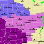
See below for what counties are under the Freezing Rain Advisory, courtesy of the National Weather Service.


Comments